

J. Mar. Sci. Eng. 2024, 12(5), 774; https://doi.org/10.3390/jmse12050774 (registering DOI) - 05 May 2024
Abstract
Oceanic energy sources, notably offshore wind and wave power, present a significant opportunity to generate green hydrogen through water electrolysis. This approach allows for offshore hydrogen production, which can be efficiently transported through existing pipelines and stored in various forms, offering a versatile
[...] Read more.
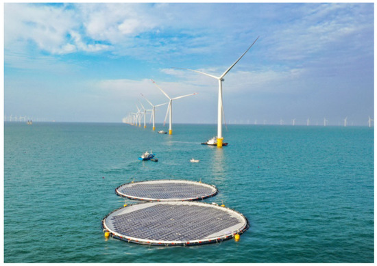
Oceanic energy sources, notably offshore wind and wave power, present a significant opportunity to generate green hydrogen through water electrolysis. This approach allows for offshore hydrogen production, which can be efficiently transported through existing pipelines and stored in various forms, offering a versatile solution to tackle the intermittency of renewable energy sources and potentially revolutionize the entire electrical grid infrastructure. This research focusses on assessing the technical and economic feasibility of this method in six strategic coastal regions in Morocco: Laayoune, Agadir, Essaouira, Eljadida, Casablanca and Larache. Our proposed system integrates offshore wind turbines, oscillating water column wave energy converters, and PEM electrolyzers, to meet energy demands while aligning with global sustainability objectives. Significant electricity production estimates are observed across these regions, ranging from 14 MW to 20 MW. Additionally, encouraging annual estimates of hydrogen production, varying between 20 and 40 tonnes for specific locations, showcase the potential of this approach. The system’s performance demonstrates promising efficiency rates, ranging from 13% to 18%, while maintaining competitive production costs. These findings underscore the ability of oceanic energy-driven green hydrogen to diversify Morocco’s energy portfolio, bolster water resilience, and foster sustainable development. Ultimately, this research lays the groundwork for comprehensive energy policies and substantial infrastructure investments, positioning Morocco on a trajectory towards a decarbonized future powered by innovative and clean technologies.
Full article
(This article belongs to the Special Issue Marine Renewable Energy and the Transition to a Low Carbon Future 2nd Edition)


